Rescuers have begun to reach areas of the northern Bahamas devastated by Hurricane Dorian, with aerial images showing a trail of destruction.PM Hubert Minnis said some areas had been "decimated" and expected the current death toll of seven would rise.The hurricane winds that hit the Abaco Islands equalled the highest ever recorded at landfall, and Grand Bahama also suffered severe damage and floods.Dorian has moved off north but still threatens the eastern US seaboard.From the air - the destruction of the Abaco IslandsHurricane Dorian: Who's at risk?Are you in the affected region? Email This email address is being protected from spambots. You need JavaScript enabled to view it..
Although the hurricane has weakened to a category two storm with maximum sustained winds of 105mph (165km/h), it has grown larger in area.
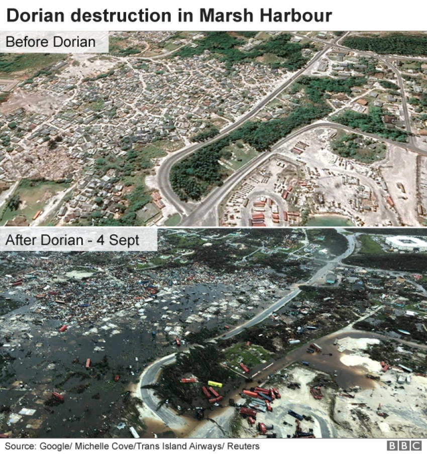
What is the damage to the Abacos and Grand Bahama?Mr Minnis confirmed the death toll had risen from five to seven, but added: "We can expect more deaths to be recorded. This is just preliminary information."It was "one of the greatest national crises in our country's history", he said.Lia Head-Rigby, who runs a relief group and overflew the Abacos, said her representatives had told her there were "a lot more dead"."It's total devastation. It's decimated. Apocalyptic," she told the Associated Press news agency.Aerial images over the Abacos, including the town of Marsh Harbour, showed mile upon mile of destruction, with roofs torn off, scattered debris, overturned cars, shipping containers and boats, and high water levels.
Opposition leader Philip Brave Davis described the scenes from a flight over the islands as a "horrible sight"Parts of the Bahamas received up to 35in (89cm) of rain.The situation on Grand Bahama is less clear, as Dorian only moved on late on Tuesday after nearly two days of pummelling, cutting many communication lines.Mr Minnis said major relief agencies had yet to get through.
Most rescue work was being done on an ad hoc basis by locals using boats and jet skis, but it was being hampered by flooded roads, fallen trees and submerged debris.One survivor in Freeport on Grand Bahama, crab fisherman Howard Armstrong, told CNN floodwaters had reached the roof of his house and his wife "got hypothermia and she was standing on top of the kitchen cabinets until they disintegrated... I kept with her and she just drowned on me".Mr Minnis said: "Our priority at this time is search rescue and recovery. It will take all of us as a caring community - government, church, businesses and individuals - to help restore the lives of our people."
Wounded people have been evacuated from the Abaco IslandsPeople have taken to social media to post lists of those they have lost contact with during the storm.The International Red Cross fears 45% of homes on Grand Bahama and the Abacos - some 13,000 properties - have been severely damaged or destroyed.Some 60,000 people will need food aid and clean water, UN officials say.A map from the Finnish satellite company ICEYE showed the extent of the flooding on Grand Bahama:
Where is the storm now?
At 09:00 GMT, the National Hurricane Centre said Dorian was centred about 350km (217 miles) north-west of Grand Bahama and about 145km east of Daytona Beach in Florida.It is moving north-northwest at 13km/h (8mph) and is expected to turn north on Wednesday evening, followed by a turn to the north-east.The NHC said Dorian was expected to weaken over the next two days but would remain a powerful hurricane.The storm would still move "dangerously close" to the Florida and Georgia coasts through Wednesday night, then the coasts of the Carolinas through Friday morning.President Donald Trump tweeted that the US "may be getting a little bit lucky with respect to Hurricane Dorian, but please don't let down your guard".
Is climate change making hurricanes worse?Scientists cannot say whether climate change is increasing the number of hurricanes, but the ones that do happen are likely to be more powerful and more destructive because of our warming climate, says BBC Weather's Tomasz Schafernaker.
Here's why:An increase in sea surface temperatures strengthens the wind speeds within storms and also raises the amount of precipitation a hurricane will dumpSea levels are expected to increase by one to four feet over the next century, bringing the potential of far worse damage from sea surges and coastal flooding during storms
Hurricane Dorian: The destruction of the Abaco IslandsShare this with Facebook Share this with Messenger Share this with Twitter Share this with
Hurricane Dorian has brought devastation to the northern Bahamas. The first aerial pictures have now emerged of the destruction on the Abaco Islands.Most of the other badly hit island - Grand Bahama, home to about 50,000 people - has still to be reached.Prime Minister Hubert Minnis said this was "one of the greatest national crises in our country's history".He also said he expected the death toll to rise.
Hurricane Dorian: Who's at risk?
1 hour ago
Share this with Facebook Share this with Messenger Share this with Twitter Share this with Email Share
Related TopicsHurricane Dorian
Image copyrightNOAA
Hurricane Dorian has left a trail of devastation across the Bahamas in its wake as it starts to edge northwards along the US east coast.
The slow-moving hurricane was the most powerful storm to hit the Bahamas since records began, bringing sustained winds of up to 165mph (270km/h) at its peak, storm surges and flooding.
It appeared to stall over the islands on Monday, intensifying the destruction.
It has now been downgraded from the highest, category five level, to category two, but officials say the storm is still producing strong gusts of 140mph and storm surges of 10ft-15ft above normal.
At least seven people have been killed by the storm in the Abaco Islands, in the northern Bahamas, and numbers are expected to rise.
The US states of Florida, Georgia, North and South Carolina have all issued states of emergency as Dorian edges northwards.
Where has been hit?
Dorian made landfall on Sunday (1 Sept) and then moved very slowly on Monday and Tuesday across Grand Bahama and the Abaco Islands in the north of the Bahamas archipelago.
High winds, heavy rain and flooding seawater have caused major damage to homes and property on the islands.
Aerial images over the Abacos showed miles of destruction, with roofs torn off, scattered debris, overturned cars, shipping containers and boats, and high water levels.
The total number of casualties is not clear as the emergency services have yet to reach some areas - but the Bahamas' PM Hubert Minnis said he expected the number of dead to increase.
The Red Cross fears some 13,000 homes have been severely damaged or destroyed by the storm.
Many people in Grand Bahama were forced to flee to the roofs of their homes to escape the rising floodwaters.
Image copyrightICEYE
Storm surges could be devastating
As well as dangerous wind speeds, authorities are warning coastal residents of life-threatening storm surges.
Storm surges are caused when huge volumes of water are pushed by hurricane-force winds. When they meet land, the water surges inshore at levels far exceeding normal tides.
Where is it heading?
The NHC is expecting Dorian to track northward, parallel to the east coast of Florida on Wednesday.
But even if the eye of the storm does not make US landfall, storm-strength winds could still blast the coastal states and storm surge warnings are in force.
Evacuations have been ordered in some coastal communities of South Carolina and Georgia and the Red Cross says more than 12,000 people spent Tuesday night in their evacuation centres,
Florida Governor Ron DeSantis said the strength of the storm should not be underestimated.
"This storm at this magnitude could really cause massive destruction. Do not put your life in jeopardy by staying behind when you have a chance to get out," he said, urging people to observe evacuation orders when they were issued.
Dorian's strength
At category five, Dorian was the second-strongest Atlantic hurricane on record, with some gusts reaching 200mph (321km/h). It is the fifth Atlantic hurricane to reach the highest category in the last four years.
Hurricane Irma in 2017 was also category five and caused widespread damage across the Leeward Islands, Caribbean and Florida keys, damaging roads, buildings, airports and harbours.
Grand Bahama was also hit by category five Hurricane Matthew in 2016 - many residents had yet to fully rebuild their houses before Dorian's arrival.